July 13, 2026
The Eclipse 2017 Path: Plan Your 2026 Solar Adventure
A friend of mine reached his 2017 viewing spot with minutes to spare, only to realize he was closer to the edge of totality than he thought. He still saw an eclipse, but not the eclipse he had driven for.
Table of Contents
- The 2017 Eclipse That Captivated a Nation
- Mapping the Great American Eclipse 2017 Path
- Location Lessons Why 99 Percent Is Not Totality
- Timing and Geometry What Shadow Speed Teaches Us
- Applying 2017 Lessons to the 2026 European Eclipse
- Archived Resources for Studying the 2017 Eclipse
- Planning Your 2026 Eclipse Trip FAQ
The 2017 Eclipse That Captivated a Nation
On August 21, 2017, the United States turned into one long observation field. Schoolyards, farm roads, rest areas, lakeshores, and fairgrounds filled with people waiting for the Moon's shadow to arrive. For many first-time viewers, the day started as a travel problem and ended as a life event.
The scale of the eclipse 2017 path helps explain why it became such a cultural moment. The Moon's umbral shadow crossed the country in a narrow band, and millions of people had to decide whether to stay home for a partial eclipse or drive to the zone of totality. That choice sounds simple on paper. On eclipse day, it meant traffic, full parking lots, crowded gas stations, and last-minute decisions about whether to move or stay put.
A day that felt larger than astronomy
Small towns suddenly mattered to people who had never heard of them before. Highway exits became strategy points. People checked clouds as often as they checked maps. The event was scientific, but it never felt abstract.
What newcomers often miss is that eclipse chasing isn't mostly about telescopes. It's about position, timing, horizon, and nerve. In 2017, plenty of people learned that the hard way. Some arrived early and had a clear, unforgettable view. Others got trapped just outside the best zone and came home wondering why their experience didn't match what totality veterans described.
Practical rule: A total eclipse rewards planning more than gear.
That's why the 2017 event still matters concerning the eclipse 2017 path today. It wasn't only a remarkable American event. It was a giant field lesson in how real eclipse travel works when many people aim for a narrow target at the same time.
Why 2017 is the right case study for 2026
The next major lesson for many European travelers comes with the total solar eclipse of August 12, 2026. The ground will be different, the road network will be different, and the viewing geometry will be different. But the core mistake is the same in every country. People assume being near the path is enough.
It isn't.
The 2017 eclipse gives newcomers a clean way to understand what matters before Europe's eclipse arrives. If you learn the geography of totality, the danger of path-edge positioning, and the timing pressure created by a fast-moving shadow, you'll make far better decisions in Spain or Iceland.
Mapping the Great American Eclipse 2017 Path
The eclipse 2017 path was the track of the Moon's umbra, the darkest central part of its shadow. If you stood inside that moving corridor, you saw totality. If you stood outside it, even very close outside it, you saw only a partial eclipse.
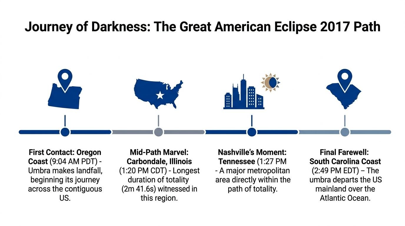
According to the U.S. Naval Observatory's 2017 eclipse data, the 2017 total solar eclipse crossed a corridor about 73 miles (118 km) wide, ran through twelve states from Oregon to South Carolina, stretched roughly 2,400 miles along its central line, and reached a longest duration of 2 minutes and 41.2 seconds near Hopkinsville, Kentucky.
What the path of totality actually is
Think of the path as a moving ribbon on the ground. It isn't a suggestion or a broad region. It's a strict boundary created by celestial geometry.
Inside that ribbon, the Moon fully covers the Sun for a short time. Outside it, some portion of the Sun remains visible. That remaining sliver changes everything, both visually and safely.
A lot of confusion starts here because maps make the band look large. On a national map, 73 miles can seem generous. On the ground, especially when roads, hills, towns, and traffic are involved, it isn't generous at all.
How the shadow crossed America
The shadow began over the Pacific and reached landfall in the Pacific Northwest. It then moved east across the continental United States, passing through a sequence of states that turned into famous eclipse destinations overnight. Oregon launched the event. South Carolina ended it.
Another official summary from NASA's eclipse path page describes the path as about 70 miles (110 km) wide, crossing 14 contiguous U.S. states from Oregon to South Carolina over about 1 hour and 40 minutes, beginning shortly after 10:15 a.m. PDT on the Oregon coast and ending near Charleston at 2:48 p.m. EDT, with the shadow moving at an average ground speed of roughly 2,200 mph (3,540 km/h).
Why the centerline mattered
The centerline is the middle of the path. That's usually where totality lasts longest. As you move toward either edge, the total phase gets shorter until it disappears entirely.
For a first-timer, this matters more than it seems. A hotel outside the centerline might still be inside totality, which is fine. But if your route, parking plan, or backup site puts you near the edge without enough margin, you give yourself less room for error.
The best eclipse map isn't the one that shows the path. It's the one that helps you decide where you'll stand if traffic, weather, or a road closure forces a change.
For Europe in 2026, this lesson becomes practical fast. Don't just pick a country or region. Pick a specific viewing area, then a backup area, then a route that keeps you inside totality even if the day gets messy.
Location Lessons Why 99 Percent Is Not Totality
The single biggest lesson from the eclipse 2017 path is simple. 99 percent is not totality. That last one percent is the whole event.
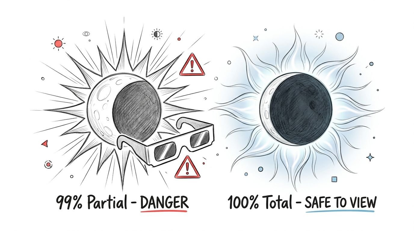
Many people assume that if the Sun is almost fully covered, the experience must be almost the same. It isn't. The visual jump from deep partial to true totality is not gradual in the way people expect. It's a threshold event.
A useful way to understand that difference is to compare the phases in this partial and total solar eclipse diagram. It shows why safe viewing rules and the visual experience change sharply when totality begins.
The edge of the path is a hard boundary
One of the most overlooked facts from 2017 is how little positional error it could take to ruin a totality plan. Reporting summarized in ABC's 2017 eclipse coverage noted that the path's width varied by state, and that a 1 to 2 mile error caused by traffic could move an observer from the full umbra into the 99% partial zone, which lacks the qualitative darkness of totality.
That's the safety paradox of a narrow path. People hear that the corridor is wide enough to be forgiving. Then eclipse-day reality cuts away that comfort. A closed road, a traffic backup, a crowded turnout, or a last-minute cloud dodge can nudge you toward the boundary.
Here's what experienced chasers do differently:
- Build a buffer: Don't target the very edge of the path unless you have a very specific reason.
- Arrive earlier than feels necessary: The right field at the wrong time is still the wrong field.
- Know your fallback spots: One primary location isn't a plan. It's a hope.
- Check your exact position on a map: "Near the path" is travel language, not eclipse language.
What observers inside totality get that others miss
Observers in totality describe a complete scene change. The Sun's bright face vanishes. The corona appears. The horizon can glow in multiple directions like a ring of sunset. The surroundings are transformed.
Observers just outside totality don't get that same transformation. They may notice dimming, odd shadows, and a dramatic crescent Sun through filters, but the world never fully tips into that brief false night.
Later in the event, this visual explanation helps anchor the difference in real time.
For 2026, this lesson is even sharper in Spain because the Sun will be low late in the day. If terrain, haze, buildings, or poor positioning steal your view, you won't have much time to recover. Being "close" won't save the moment.
Timing and Geometry What Shadow Speed Teaches Us
Most beginners obsess over duration and forget motion. But the eclipse is not a static sky show. The shadow is moving, and that motion shapes every local decision you make.
During the 2017 eclipse, the Moon's shadow slowed from 1,850 mph to 1,660 mph across Wyoming, as noted by EclipseWise's Wyoming state analysis. That change matters because local timing is tied to where you are under a shadow that doesn't move at one fixed speed everywhere.
A moving shadow changes local decisions
If you think only in terms of "the eclipse starts around this time," you're missing how narrow the useful decision window can become. In practice, eclipse chasers make choices under pressure.
They decide whether to move for a gap in the clouds. They decide whether a hill blocks too much of the sky. They decide whether staying put is safer than driving a few miles. The speed of the shadow turns all of that into a countdown.
For first-time observers, three timing habits matter:
- Know local eclipse times for your exact spot. Not your hotel town. Not the nearest city. Your exact viewing site.
- Stop moving early. A last-minute relocation feels smart until everyone else tries the same thing.
- Rehearse the sequence. Glasses on during partial phases. Filters handled correctly. Eyes up when totality begins.
A good eclipse plan has a clock in it, not just a map.
If you want a refresher on the sky mechanics behind this, the primer on solar and lunar eclipse basics is useful before you start comparing local timelines.
Why Spain in 2026 adds a new challenge
The 2017 American eclipse often gave observers a comfortably high Sun. That made basic site selection easier. Trees, ridges, and city buildings could still matter, but they didn't dominate the experience in the same way.
Spain in 2026 is a different problem. The sunset geometry means the Sun will be low, which makes the western horizon essential. A site that looks perfect at noon can fail badly near sunset if hills, apartment blocks, haze, or even a line of trees intrude.
That low-Sun setup changes the meaning of timing. You aren't only racing the shadow. You're also working against the descending Sun. The result is a harder deadline and a stronger need to scout your horizon in advance.
Applying 2017 Lessons to the 2026 European Eclipse
If the eclipse 2017 path taught one strategic lesson, it's this. Success comes from combining exact location with flexible logistics. Europe in 2026 rewards that same mindset.
The broad outlines of the 2026 event are already clear. According to Poseidon Expeditions' 2026 eclipse summary, the path of totality on August 12, 2026 will be about 293 km (182 miles) wide and will cross Greenland's eastern coast, western Iceland, and the Iberian Peninsula before reaching the Balearic Islands.
What the 2026 path looks like
This is not a repeat of 2017 in a different location. The geography changes the whole planning style.
Iceland offers dramatic scenery and relatively open horizons in many places, but travelers still need a mobility plan if clouds build. Spain offers more road options and many excellent western viewpoints, but the low Sun adds pressure. You can't treat any place inside the path as equally good.
Another useful reference point is the maximum duration. The 2026 eclipse overview notes that the point of greatest duration lies just off Iceland's western coast, where totality reaches 2 minutes and 18.21 seconds.
A practical planning framework for Europe
A newcomer doesn't need dozens of tabs open. You need a short list of decisions made in the right order.
- Choose by horizon first: In Spain, a low western view matters as much as being inside the path. Coastlines, open plains, and higher locations with a clean western outlook deserve extra attention.
- Then choose by mobility: A base with multiple road options is better than a beautiful dead-end viewpoint.
- Treat accommodation as separate from viewing: Sleep where it makes sense. Watch where the sky makes sense.
- Scout two classes of backup: One backup for clouds, another for access problems such as parking or crowding.
The best 2026 site may not be the place with the longest totality. It may be the place you can reach reliably, with a clear horizon, while still keeping a weather backup alive.
For photographers, this matters even more. A low Sun can produce a striking scene, but it also punishes a poor foreground choice. If your western view is cluttered, no camera setup will fix that.
Eclipse Comparison 2017 USA vs. 2026 Europe
| Parameter | 2017 'Great American' Eclipse | 2026 'Iberian' Eclipse |
|---|---|---|
| Path width | Approximately 73 miles (118 km) according to the U.S. Naval Observatory | Approximately 293 km (182 miles) according to Poseidon Expeditions |
| Main land track | United States from Oregon to South Carolina | Western Iceland and the Iberian Peninsula, continuing to the Balearic Islands |
| Shape of planning problem | Narrow land corridor with major interstate travel pressure | Wider path in key regions, but stronger importance of site selection and horizon quality |
| Solar altitude challenge | Generally more forgiving for many observers | Sunset geometry creates a low-Sun viewing challenge in Spain |
| Best lesson carried forward | Exact placement inside totality | Exact placement plus a clear western horizon and day-of flexibility |
Archived Resources for Studying the 2017 Eclipse
If you want to prepare seriously for 2026, don't only read travel guides. Study archived material from 2017 and train your eye to recognize what matters.
Maps and official path references
Start with official mapping and geometry. These aren't glamorous, but they teach the right mental model.
- U.S. Naval Observatory eclipse data: Best for understanding the official track, scale, and duration structure across the United States.
- NASA's 2017 eclipse path page: Useful for timing, entry and exit across the country, and the speed of the moving shadow at a continental scale.
- State-level eclipse path archives: Helpful when you want to see how local conditions changed along the route rather than thinking of the eclipse as one uniform event.
When you review maps, don't just ask where totality happened. Ask where the path narrowed, where major road corridors intersected it, and where a backup move would have been realistic.
What to study in photos and observer reports
Photo galleries and first-person reports teach a different lesson. They show what totality looks like in reality rather than on a clean astronomical diagram.
Look for these specific features in archived images and narratives:
- Baily's Beads: These help you understand how quickly the visual scene changes right at the edge of totality.
- The diamond ring effect: Useful for timing expectations and camera restraint.
- Horizon glow: A strong reminder that totality is a regional event, not only a solar close-up.
- Crowd behavior: Reports from roadsides, parks, and open fields teach practical lessons about parking, setup, and exit strategy.
A good self-study routine is simple. Read one official path reference, then one observer report, then review images from the same region. That combination gives you geometry, logistics, and human experience in one sitting.
Planning Your 2026 Eclipse Trip FAQ
Is Iceland or Spain better for a first eclipse
It depends on what kind of problem you'd rather solve. Iceland can offer striking scenery and open viewpoints, while Spain may offer easier ground logistics in many areas. Spain also demands more care with the western horizon because the Sun will be low late in the day.
If you're still choosing, a location guide for where to see the total solar eclipse in 2026 can help narrow the shortlist.
How early should I book
Book once you've chosen a region, but don't lock your entire plan around a single fixed viewpoint. Keep your lodging and your viewing strategy separate in your head. The 2017 lesson still applies. Sleeping in one place doesn't mean you should watch from there.
What should my Plan B look like
A good Plan B is nearby enough to reach without panic and different enough to solve a real problem. If your main site fails because of clouds, the backup should change the weather odds. If your main site fails because of terrain or crowding, the backup should change access and horizon quality.
Write down the route, parking assumptions, and turnaround point ahead of time. Don't improvise all of that on eclipse day.
What camera approach is safest and simplest
For a first eclipse, keep the setup modest. A tripod, a simple telephoto or compact camera, eclipse glasses for the partial phases, and a written sequence are more useful than a complicated rig you haven't practiced with. Many first-timers miss the emotional experience because they spend the best seconds troubleshooting gear.
Should I chase weather on the day
Yes, but only within limits. Mobility helps. Last-second chaos doesn't. The safest pattern is to prepare multiple viewing zones in advance, then choose among them based on conditions rather than inventing a brand-new plan under pressure.
What's the one mistake I should avoid
Don't settle for "almost in the path." That decision caused regret in 2017, and it will do the same in 2026. If totality is the goal, your viewing site must be well inside the path and suitable for the Sun's position at that hour.
If you're planning to see the August 12, 2026 eclipse in Europe, Total Solar Eclipse 2026 Live is a practical place to start. It brings together path geometry, city timing, safety guidance, horizon planning, and trip-focused tools for Spain, Iceland, and viewers across Europe.