July 10, 2026
Partial Solar Eclipse Diagram: Essential 2026 Guide
You've probably already done the first thing every eclipse traveler does. You open a map for August 2026, see curves across Europe, shaded zones, contact times, and labels like penumbra or totality, and then realize the diagram is telling you something important without making it obvious.
That confusion matters more for this eclipse than for many others. In northern Spain, the Sun will be low in the west during totality, so reading a diagram isn't just an academic exercise. It helps you decide whether your hotel balcony, beach, hilltop, or roadside turnout will give you a view.
A good partial solar eclipse diagram is a planning tool disguised as a science graphic. Once you know what the shadows mean, where the path sits, and how a local sky view relates to your horizon, the lines stop looking abstract. They become instructions for where to stand and when to look up.
Table of Contents
- Planning for the 2026 Eclipse Starts Here
- The Geometry of an Eclipse What a Diagram Shows
- Decoding the Views How to Read Common Eclipse Diagrams
- The 2026 Sunset Eclipse A Practical Example
- Why 99 Percent Is Not Totality
- How to Create Your Own Accurate Eclipse Diagram
- Your Roadmap to Witnessing the 2026 Eclipse
Planning for the 2026 Eclipse Starts Here
A traveler books a few nights in northern Spain, pulls up an eclipse map, and assumes the hardest part is finished. Then the key questions begin. Is the town inside the path of totality, or only in the partial zone? Will the Sun be above the sea, behind a ridge, or hidden by apartment blocks? Does a dramatic-looking map accurately tell you what the sky will look like from ground level?
Those are the right questions. The diagrams people skip past are often the difference between seeing the event and missing the best part of it.
For August 2026, Europe gets an eclipse that rewards careful planning. The broad maps help you choose a region. The side-view diagrams explain the shadow geometry. The local-sky charts tell you whether your chosen lookout has a usable western horizon. If you want a feel for how the event unfolds over time, a 2026 eclipse time-lapse animation makes the motion much easier to picture than a static map.
Practical rule: Don't choose a viewing site from a path map alone. Choose a region from the map, then confirm the western horizon from a local sky simulation.
People often think a partial solar eclipse diagram is only for viewers outside totality. It's more useful than that. It teaches you how the Moon's shadow spreads across Earth, how eclipse phases unfold, and why being slightly in the wrong place can change the experience completely.
The Geometry of an Eclipse What a Diagram Shows
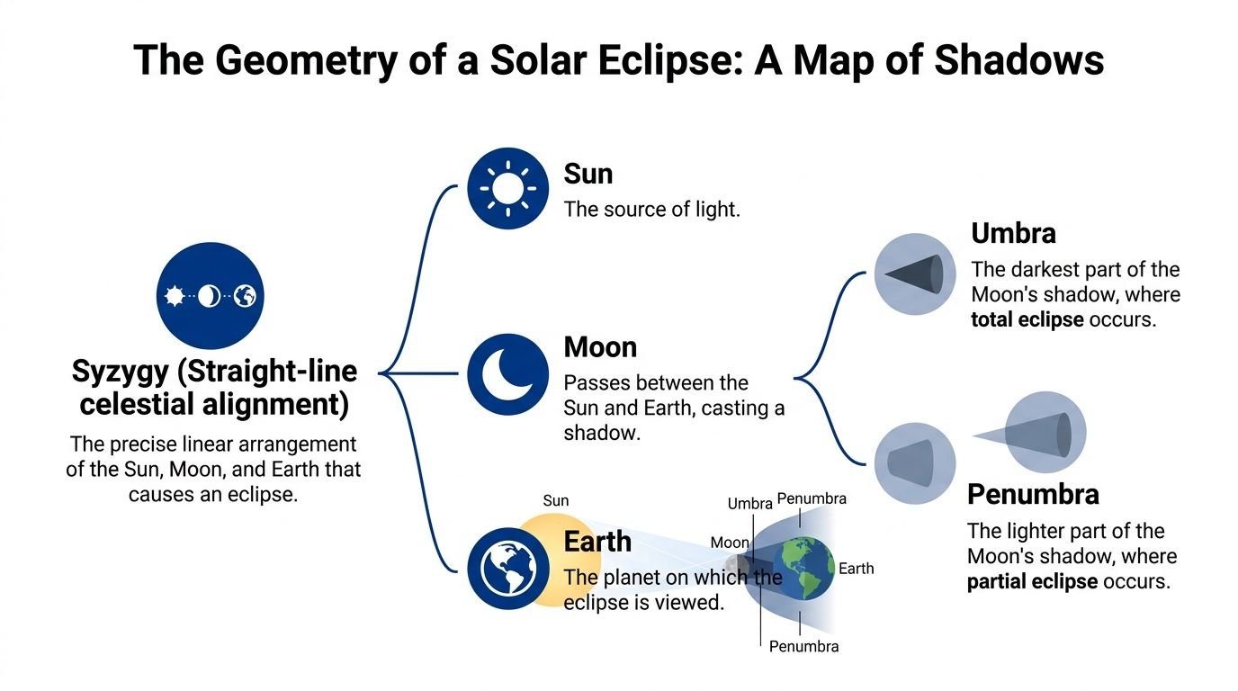
A good eclipse diagram is not just astronomy homework. For the August 2026 eclipse in Spain, it helps answer a practical question: will the low Sun still be visible from where you stand, or will a hill, ridge, or row of buildings hide the best part?
Start with the alignment
Every solar eclipse begins with the Sun, Moon, and Earth lined up. Astronomers call that syzygy. It happens at new moon, which is the only lunar phase that can produce a solar eclipse, as explained in this guide to solar and lunar eclipses.
In a diagram, that lineup looks tidy. Real viewing is less tidy. The Sun is the light source, the Moon slides in front of it, and Earth sits where the Moon's shadow falls. What matters to you on the ground is not only where the bodies are, but which part of the shadow reaches your location and where the Sun sits above your horizon at that moment.
The shadow has layers
The Moon's shadow works like the shadow from a small ball lit by a bright lamp. Right behind the ball is a dark, narrow core. Around it is a broader, lighter zone where only part of the light is blocked.
Eclipse diagrams label those regions as the umbra and the penumbra. If you stand in the penumbra, the Moon covers only part of the Sun. If you stand in the umbra, the Sun is fully covered and you get totality.
That distinction is the heart of the geometry. A partial solar eclipse diagram is really a map of where the penumbra falls. The broad outer shadow can wash across a large part of Europe, while the dark central shadow traces a much narrower route or misses a given place entirely. For 2026, that difference shapes travel decisions. A town may look promising on a regional map, yet still give you a weaker experience than a better-placed lookout with a wide, open western horizon.
Read the diagram as an observer map. Ask, “Which shadow reaches me, and where will the Sun be in my sky when that happens?”
Why the side view matters
Top-down maps are great for choosing a region. The side view explains why the event looks different from one place to another.
A side-view diagram shows the shadow cone tapering away from the Moon toward Earth. That cone is easiest to understand if you picture a flashlight beam narrowed by an object in front of it. The central dark part is slim. The lighter outer part spreads wider. If Earth only intersects the outer part, the eclipse is partial everywhere shown in that diagram.
This matters for Spain in 2026 because the eclipse occurs late in the day. Near sunset, the geometry in space meets local geography on the ground. A diagram may show strong coverage for your location, but if the Sun is only a few degrees above the western horizon, a distant ridge can erase the finale. The diagram tells you the celestial setup. You still need a site where the western sky is open.
The phases a diagram usually marks
Many eclipse diagrams also mark the event as a sequence, because an eclipse is motion, not a single frozen moment.
- First contact marks the moment the Moon first appears to touch the Sun's edge.
- Maximum eclipse is the point of greatest coverage for that location.
- Last contact is when the Moon finally leaves the Sun's disk.
Those labels help you connect the geometry to timing. If maximum eclipse for your Spanish viewpoint happens very close to sunset, your diagram is telling you something practical. The last minutes may be the most dramatic, but they are also the easiest to lose behind terrain or buildings.
A partial-only diagram gives another useful clue. If it shows penumbra, timing marks, and no total phase, then the geometry for that setup never places you inside the Moon's dark central shadow. You are watching a bite taken from the Sun, not day turning briefly to night.
One final point belongs next to every diagram. During all partial phases, you need ISO 12312-2-compliant eclipse glasses. The drawing may look neat and gentle. The actual Sun remains bright enough to injure your eyes until the Sun is fully covered, and in a partial eclipse that full coverage never happens.
Decoding the Views How to Read Common Eclipse Diagrams
A single eclipse can generate several diagram styles, and each answers a different question. If you try to use the wrong one, planning gets muddy fast.
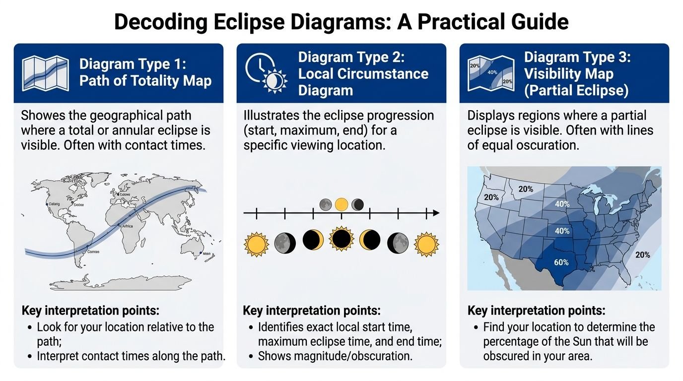
The map view for travel decisions
The first type is the path map. This is the widely recognized top-down view. It shows where the eclipse shadow crosses Earth's surface and which regions get total, annular, or partial visibility.
Use this map for decisions like these:
| Diagram type | Best question it answers | What to look for |
|---|---|---|
| Path map | Where should I travel? | Whether your town is inside or outside the path |
| Local circumstance chart | When does it happen here? | Start, maximum, and end for one location |
| Visibility map | How much of the Sun is covered in this region? | Broad shaded areas and equal-coverage lines |
A path map is powerful, but limited. It can tell you that your chosen town is correctly placed. It can't tell you whether a hill blocks the low Sun to your west.
The side view for understanding shadow cones
The second type is the cross-section or side-view diagram, which makes a partial solar eclipse easiest to understand. You see the Sun, Moon, Earth, and the tapering shadow cones from the Moon.
This diagram doesn't help much with hotel booking, but it solves common confusion. Why is totality so narrow? Why can one city get a dramatic event while another, not far away, only gets a partial bite from the Sun? The side view makes that clear by showing the narrow central shadow and the much wider outer shadow.
For many readers, this is the moment eclipse geometry clicks. You stop memorizing terms and start seeing the mechanics.
A short visual explainer helps if you want to compare diagram styles in motion:
The local sky view for your actual horizon
The third type is the one many travelers discover too late. The local sky view shows the eclipse as seen from one exact location. It places the Sun on an arc in the sky and marks the Moon's movement across it.
This is the format that tells you whether you need a rooftop, beach, clifftop, or open field. For Spain in 2026, that matters a lot because the Sun will be low late in the day.
Look for these details in a local sky diagram:
- Altitude of the Sun tells you how high it will be above the horizon.
- Azimuth tells you the compass direction. For Spain, the western horizon is the one that matters most.
- Phase timing shows whether the deepest part of the eclipse arrives before the Sun drops behind terrain or buildings.
A path map answers “Am I in the right town?” A local sky diagram answers “Can I actually see the eclipsed Sun from this exact spot?”
When people mix these up, they choose a technically correct location with a terrible sightline. That's the planning mistake to avoid.
The 2026 Sunset Eclipse A Practical Example
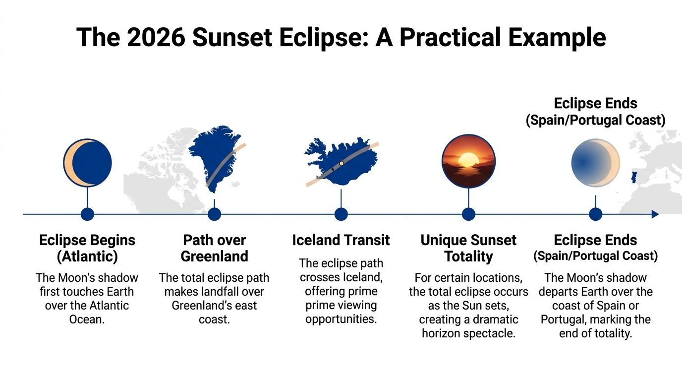
You arrive in northern Spain late in the afternoon, check the eclipse map, and feel confident. Your town sits inside the path. Then you look west and find a ridge, a hotel block, or a row of apartment roofs exactly where the Sun will sink. The diagram was right, but your viewing spot was wrong.
That is why Spain turns eclipse geometry into a field decision. For this eclipse, the abstract lines on a map have to be translated into one practical question. Will the low Sun still be visible from where you are standing?
What makes Spain different
This eclipse is unusual because many viewers in Spain will be dealing with a Sun that is already dropping toward the western horizon during the main event. A path map still matters, but it no longer answers the whole problem. It tells you whether the Moon's shadow reaches your area. It does not tell you whether a hill, tree line, or waterfront construction crane reaches your sunset line first.
A local sky diagram becomes much more useful here than it would be for a high-noon eclipse. It works like a side-view sketch of the event. Instead of showing the shadow crossing Earth, it shows the Sun's track through your own sky and the Moon taking a bite across that disk. For Spain, that side view is the one that helps you choose between a beach, a mirador, an open farm road, or a town square with too much built-up horizon.
The practical consequence is simple. A technically excellent location can fail at the last minute if the western horizon is cluttered.
How to choose between path, weather, and horizon
Suppose you are comparing a coastal turnout, an inland hill, and the edge of a historic town. All three may look good on a broad eclipse map. The difference appears when you layer the diagrams onto the actual world.
The path map answers, "Is this place inside totality or only in a deep partial zone?"
The local sky view answers, "Where exactly will the Sun be?"
Your site check answers, "Can I see that patch of sky without obstruction?"
Weather adds another layer. Earlier planning resources note that some inland areas in Spain can offer better cloud prospects than parts of the coast in August, while many coastal sites offer cleaner sunset sightlines over the sea. That tradeoff matters more for this eclipse than for one with the Sun high overhead.
Here is the kind of comparison that helps on the ground:
- Coastal sites often give you the cleanest western horizon, which is a major advantage when the Sun is low.
- Inland sites may offer better chances of clear sky in some regions, but even a modest ridge can block the final minutes.
- Urban sites are easy to reach, yet rooftops, street orientation, and nearby buildings can cut off the sunset view.
- High viewpoints can be excellent if the slope falls away to the west. They can be poor if a second ridge sits in front of you.
A good Spain plan balances all three factors at once: being in the right shadow zone, having a reasonable shot at clear skies, and seeing all the way to a low western Sun.
A practical site checklist
Use the diagram the way a pilot uses a chart. It is not decoration. It is a decision tool.
- Confirm the eclipse type at your exact location. A nearby town may get totality while your chosen overlook gets only a partial phase.
- Check the Sun's low-angle direction. "West" is not precise enough on its own. You want the actual sunset-side bearing for your coordinates.
- Test the horizon, not just the map. Street-level photos, terrain views, and an in-person visit can reveal obstacles a regional map hides.
- Favor sightline over theory when the difference is small. A spot slightly away from the ideal center can be better if it gives you a wide, open view of the Sun.
- Keep a backup site ready. For a low-Sun eclipse, a short drive can change both your cloud outlook and your horizon quality.
One mistake shows up again and again with sunset eclipses. Viewers focus on the shadow path as if the event happens overhead. In Spain, the event happens near the edge of your visible world. That changes how you should read every diagram.
If you are using a partial solar eclipse diagram to plan for Spain, treat it as the first filter, not the final answer. The winning location is the one where the geometry on paper still works when you turn around, face west, and look at the actual horizon.
Why 99 Percent Is Not Totality
A map can make 99% look close enough. It isn't.
The reason is physical, not emotional. The Sun's visible surface is so bright that even a tiny exposed sliver keeps the surroundings much brighter than observers might anticipate. That's why a deep partial eclipse can feel strangely normal compared with the shock of totality.
Why the light stays stronger than you expect
For partial eclipses, brightness doesn't fall in a neat, proportional way with the covered area of the Sun. Even at 90% solar coverage, ambient brightness remains near 10–15% of full daylight due to atmospheric scattering, as discussed in this astronomy discussion about partial eclipse brightness.
That's the key idea many standard diagrams leave out. Your eyes and the atmosphere don't respond linearly to the shrinking solar crescent. The sky often stays much brighter than the diagram suggests.
A useful analogy is a dark theater with one spotlight still on. Dim most of it and the room still doesn't look dark. The remaining beam dominates the scene.
What only totality gives you
Totality is not “a little more eclipse.” It's a different category of event.
During a deep partial eclipse, you can watch the Sun become a thinner and thinner crescent through safe filters. During totality, the bright photosphere disappears completely, and the whole visual environment changes. The sky drops toward twilight. The corona becomes visible. The horizon takes on the strange all-around sunset look eclipse chasers talk about for years afterward.
If you travel for an eclipse, the line between deep partial and totality is the line that matters most.
That's why a partial solar eclipse diagram can be deceptive for beginners. The coverage contours look smooth and gradual. The experience is not. It changes abruptly when you cross into the path where the Moon fully covers the Sun.
How to Create Your Own Accurate Eclipse Diagram
A good eclipse diagram becomes far more useful when it is built for the exact place you plan to stand. For the 2026 eclipse in Spain, that matters because the Sun will be low in the western sky late in the event. A site that looks perfect on a national map can fail in real life if a ridge, apartment block, or line of trees sits where the Sun needs to be.
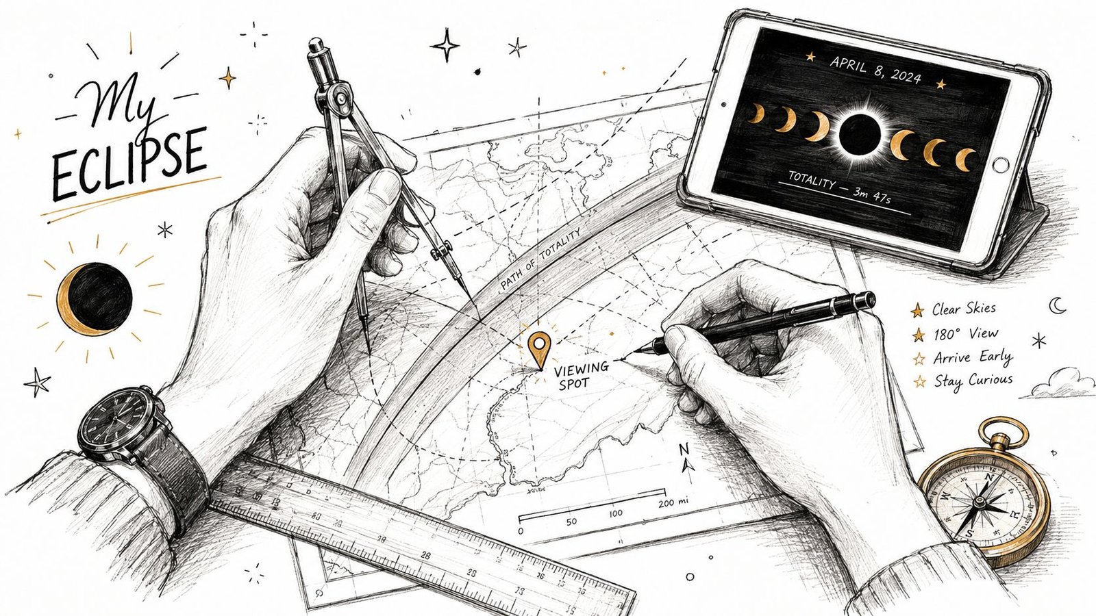
The tools worth using
Each planning tool shows a different slice of the problem.
- Stellarium helps you simulate the sky from one exact location. It is the easiest way to see where the eclipsed Sun will sit above the horizon as the event progresses.
- Time and Date's eclipse tools are useful for local timing. They answer practical questions such as when the eclipse begins, when maximum eclipse occurs, and how close sunset is.
- Xavier Jubier's interactive eclipse maps help with geographic precision. They show where the path falls on the ground, which is helpful when you are comparing one beach, overlook, or inland turnout with another.
Used together, these tools work like layers on tracing paper. One layer shows the shadow path. Another shows the clock. Another shows the sky from your own viewpoint.
A simple workflow for one real location
Start with one candidate site, not a whole region. A diagram made for "northern Spain" is too broad to answer the question that matters on eclipse day: will the Sun still be visible from this exact spot?
Enter the coordinates of your chosen location and set the event date for the 2026 eclipse. Then generate the local sky view and follow the Sun through the final part of the event, especially as it drops toward the west.
Next, compare the simulation with the actual horizon. If the software shows the Sun only a few degrees above the horizon, treat that like a flashlight beam skimming across a table. Even a small object in the beam can block it. A low hill several kilometers away, a hotel roof, or a row of tall pines can matter more than the path map suggests.
Then test a few nearby alternatives. Moving from a town center to a beach access point, harbor wall, open field, or roadside pullout can completely change your western view.
A practical checklist helps:
- Confirm the eclipse zone. Check whether the site lies inside the path of totality or in the partial zone.
- Simulate the late sky. Focus on the Sun's altitude and compass direction during the last stages, not only at maximum eclipse.
- Inspect the west. Use satellite view, street-level imagery, topographic maps, or a scouting visit to judge whether the horizon is open.
- Keep a backup site. If clouds threaten one area, a second location with a similarly clear western horizon gives you options.
What to verify before eclipse day
The best self-made diagram combines astronomy with ordinary fieldcraft. You are not only drawing the Sun, Moon, and shadow geometry. You are also asking where your feet will be, what blocks your line of sight, and whether you can still see the Sun as the eclipse approaches sunset.
For Spain, this changes real travel decisions. A dramatic clifftop viewpoint may sound ideal, but a flat inland site with an unobstructed west can be the better choice if the Sun will be grazing the horizon. That is the practical value of making your own diagram. It turns abstract geometry into a yes-or-no answer about one location.
Safety belongs in the same plan. During every partial phase, you need certified eye protection or a proper solar filter. Review the eclipse safety guidance for ISO 12312-2 viewing before you finalize your setup.
Build the diagram for the place where you will actually watch. That is how an eclipse map becomes a field guide instead of a rough guess.
Your Roadmap to Witnessing the 2026 Eclipse
A partial solar eclipse diagram stops being intimidating once you know what it's really showing. It's a shadow map, a timing guide, and for this particular event, a horizon-planning tool.
For Europe in August 2026, that last part matters more than usual. Spain offers a rare sunset eclipse setting. Iceland offers a different geometry and a different travel style. In both cases, the winning habit is the same. Read the path map first, then test the exact local sky, then verify your actual view line.
Keep the science simple and practical. Penumbra means partial. Umbra means totality. A location inside the right zone still needs the right horizon. And all partial phases require proper eye protection, so review eclipse safety guidance for ISO 12312-2 viewing before eclipse day.
If you do that work ahead of time, the diagrams won't feel abstract anymore. They'll feel like what they are. A map to one of the most memorable sky events Europe will see in 2026.
If you're planning where to watch in Europe, Total Solar Eclipse 2026 Live is a useful place to check city-by-city timing, path details, planning guidance, and safety information for the 12 August 2026 event.