July 25, 2026
Collioure France Map: Interactive & Printable Guide
You might be standing on the quay with a dead battery, trying to decide whether the bell tower is left, right, or somehow above the harbor wall. That's the moment a Collioure France map stops being a nice extra and becomes the thing that saves your afternoon. In a town this compact, with lanes that pinch into stairs, a harbor that curves around the old core, and viewpoints that climb fast, the wrong map wastes time and the right one turns a quick visit into an easy walk.
Collioure rewards people who arrive oriented. Its beauty is obvious, but its geography is not simple, especially if you're arriving by train, parking on the edge of town, or linking the visit to a longer Spain-bound trip. The most useful way to plan here is to think map first, sights second, logistics third. That keeps you from circling the same lanes twice and helps you decide what to do before the town gets busy.
Table of Contents
- Why a Good Map Matters in Collioure
- Placing Collioure on the Map
- The Best Collioure France Map Tools
- A Walking Map of Collioure's Old Town
- Getting to Collioure and Parking
- Key Sights to Plot on Your Map
- Regional Context and Map Planning Beyond Collioure
Why a Good Map Matters in Collioure
The first useful habit in Collioure is to stop trusting instinct at the waterfront. A visitor steps off the train, checks a phone with half a charge, and starts hunting for bread, shade, or the route to the lighthouse. That's exactly where a clear map earns its keep, because the town's tight medieval lanes, stair-stepped streets, and split-level shoreline make “just walk that way” a poor strategy.
A collioure france map is more than a sightseeing aid here, it's a tool for reading the town's shape. The harbor sits against the old core, the castle edges one side of the waterfront, and the headland rises quickly behind the church tower. If you know where those anchors sit before you start walking, you can decide whether you're doing a flat loop, a climb, or a mixed route with rest stops built in.
Practical rule: In Collioure, the map should tell you where the slope starts before your legs do.
That matters because the town doesn't behave like a regular grid. Streets narrow, turn pedestrian-only, and fold upward into lanes that look close on a screen but feel much farther on foot. A paper map with the waterfront, the church cluster, and the hill paths marked in advance is often faster than a phone, especially if you're stopping for photos or losing signal in the tighter lanes.
The rest of this guide follows that logic. First comes orientation, then walking routes, then arrival and parking, then the broader regional context for anyone combining Collioure with Spain or the eastern Pyrenees. If you keep the map in hand, the town stays charming instead of confusing.
Placing Collioure on the Map
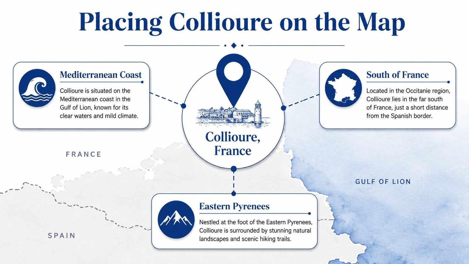
Collioure sits on the Mediterranean coast in the Gulf of Lion, in the Pyrénées-Orientales department, just a few kilometers north of the Spanish border, and that position explains almost everything about the town's feel and function. One published coordinate places it at 42.526° N, 3.0813° E (Wikipedia's Collioure entry). Another georeferenced listing gives 42.526752° N, 3.084631° E (LatLong's Collioure page). The difference is just how map services round or pin the same harbor area, not a contradiction in location.
If you look at a map with those coordinates in mind, Collioure is easy to place. It belongs to southern France, on the coast that runs toward the eastern Pyrenees, and it sits close enough to Spain that cross-border travel becomes a practical part of trip planning. That's why the town often works as a hinge point between a French coastal stay and a Catalan itinerary.
The geography also gives you a useful sense of direction. The sea lies to the east, the land rises toward the west and south, and the border sits close enough that Collioure can be used as a reference when plotting onward travel into Catalonia. If you're thinking about sunset, a harbor-facing viewpoint is the one to keep in mind, because the town's coastal edge opens onto the Mediterranean rather than inland valleys.
For broader route planning, the key takeaway is simple. Collioure isn't an isolated inland stop, it's part of the Occitanie coastal margin and the old Languedoc-Roussillon seafront identity, which makes it easy to fold into a borderland trip without adding much complexity. If your journey also includes Barcelona, a dedicated city reference can help you think through the southern end of the route, especially when comparing the French coast with the Catalan side (Barcelona eclipse city guide).
The Best Collioure France Map Tools
A good Collioure map setup usually needs three layers. The first is an interactive map for live navigation, the second is a printable map for offline walking, and the third is a neighborhood or route map for the old core where alleys blur together. Each one solves a different problem, and none of them does the whole job alone.
Interactive tools such as phone map apps or tourism portals are best when you're searching for a café, the nearest car park, or a route back from the beach. They're also the easiest way to drop a pin near the civic center at 3 rue de la République, 66190 Collioure (Cartes France's Collioure page). That address is a useful landmark when you need a fixed reference for local coordination or want a stable search term in French routing tools.
Printable maps earn their place the moment roaming gets patchy or your battery starts sinking. They're better for a slow walk through the old town, where you're making decisions based on slope, shade, and which lane is pedestrian-only. A tourist-office sheet or a printed walking plan is often easier to annotate with the route you want to take.
Neighborhood maps are the most underrated option. They're not for long-distance planning, they're for those turns where the street names stop helping and the town becomes a maze of stone walls, stairs, and small openings to the water.
| Map Type | Best For | Limitation |
|---|---|---|
| Interactive map | Live navigation, restaurants, parking, quick rerouting | Can be awkward when signal drops or streets get too narrow for fast use |
| Printable map | Offline walking, slow sightseeing, marked-up loops | Less useful for real-time changes |
| Neighborhood map | Old-town lanes, slopes, and landmark-to-landmark walking | Too local for broader travel planning |
Best practice: Save one digital map, carry one paper map, and mark the mairie address before you arrive. That mix works better than relying on a single app.
The postal code 66190 is also worth using in French search tools, especially when you're checking access, parking, or local services. It's a small detail, but in a town this compact, small details save time.
A Walking Map of Collioure's Old Town
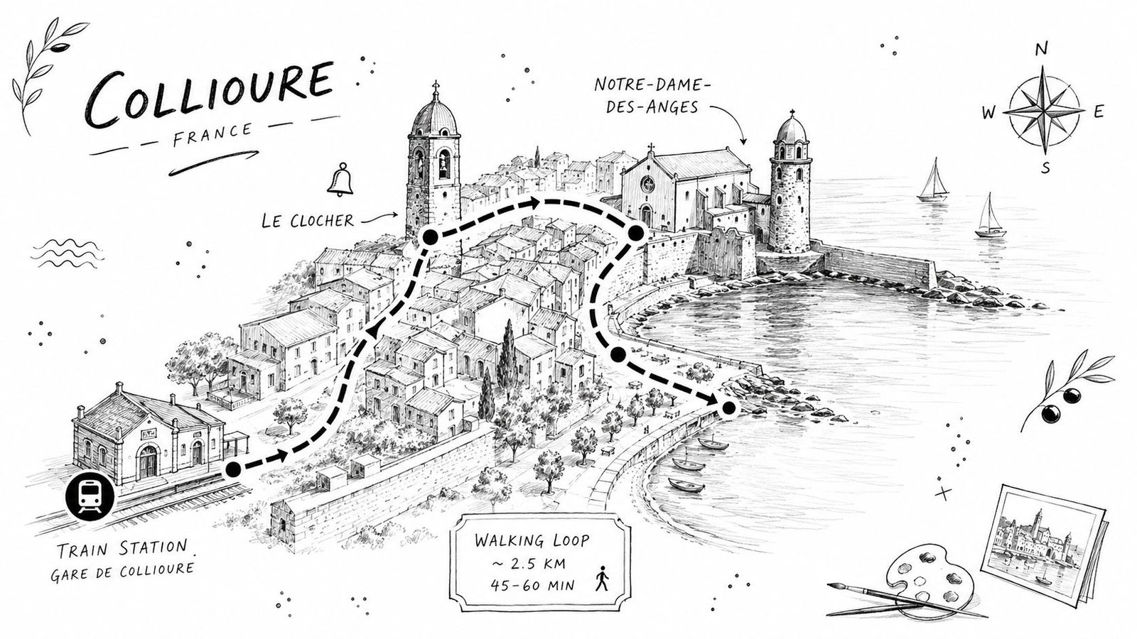
Start at the train station or at an edge-of-town parking area, then use the bell tower and Notre-Dame-des-Anges as your first visual anchor. Once you've got that pair in view, the town becomes legible very quickly, because the waterfront, the castle, and the church cluster all sit within a short, walkable arc. A marked paper map helps here more than a phone because the road becomes a lane, then a stair, then a view.
The easiest half-day loop follows the quay past the Château Royal de Collioure and toward Boramar beach. That stretch gives you the classic harbor scene, and it's the best place to feel how the town wraps around the water rather than facing it in a straight line. Keep a hand on the map if you want to stay on the flatter ribbon along the harbor, because the side streets begin climbing faster than they look.
From there, the painted lane network starts pulling upward toward the Moulin de Collioure and the chapel on the hill. A paper map is better than glass. The slope is easier to judge on a printed map, and the pauses feel more natural when you can see the route unfold in front of you.
The lanes above the waterfront turn pedestrian-only in places, and that's part of the charm, not a problem. A few shaded benches break up the climb, and the corners above the harbor often give you the most photographed vantage points in town. If you want the cleanest views, stop where the old town opens toward the sea instead of trying to force a perfect photo from the narrowest alley.
The town is small, but the elevation changes are real. If you're short on time, work the loop from the water upward rather than the other way around.
Getting to Collioure and Parking
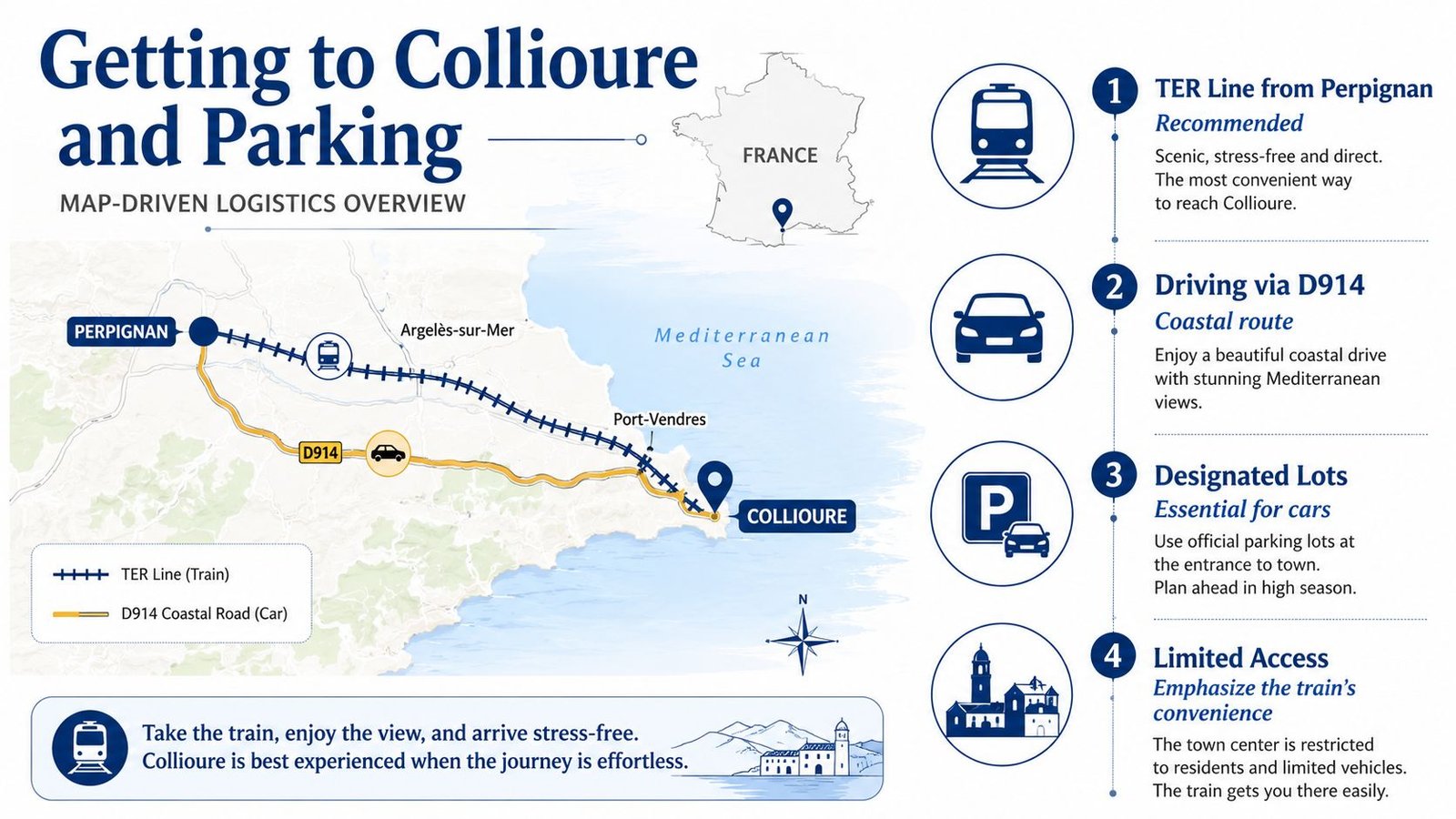
Collioure's mapped position near the border makes the train the least stressful way in for many visitors. A regional TER line from Perpignan is usually simpler than driving because the town's access funnels toward a single coastal approach, and once you're in the historic core, cars stop being useful very quickly. If you arrive with luggage, the station-to-town walk is manageable and avoids the parking hunt altogether.
Driving still works, especially if you're pairing Collioure with vineyards or a wider Pyrenees loop. The practical trade-off is that the compact medieval center leaves little room for easy street parking, so the best plan is to aim for designated lots on the outskirts and walk in. That keeps the old lanes clear and saves you from circling the center for a space you probably won't find.
The civic pin at 3 rue de la République is a sensible reference point if you need to orient yourself once you're close. The town center doesn't need much decoding after that, because the harbor and the old streets are tightly packed around the same core. If you're coming from farther south or building a Catalonia itinerary, the Spanish border proximity makes Collioure a useful stop on the way between France and Spain, not just a detour from one to the other. For travelers who are also tracking the eclipse conversation in Spain, this regional planning note is worth saving: Spanish eclipse planning for 2026.
The nearest major air and road connections are best understood as a geography problem, not a timetable problem. Perpignan sits to the north, while Girona and Barcelona sit across the border to the south, so Collioure works well as a middle point for mixed French-Catalan travel. In practical terms, that means you can choose a rail-first visit, a car-based coastal loop, or a broader Spain-facing itinerary without changing the logic of your map.
Parking rule: If you want the easiest day, arrive early, leave the center to pedestrians, and treat parking as a perimeter task rather than something to solve at the waterfront.
August adds pressure. The streets are tight, the demand is higher, and patience drops fast when everyone reaches the same lanes at the same time. An early arrival changes the whole experience.
Key Sights to Plot on Your Map
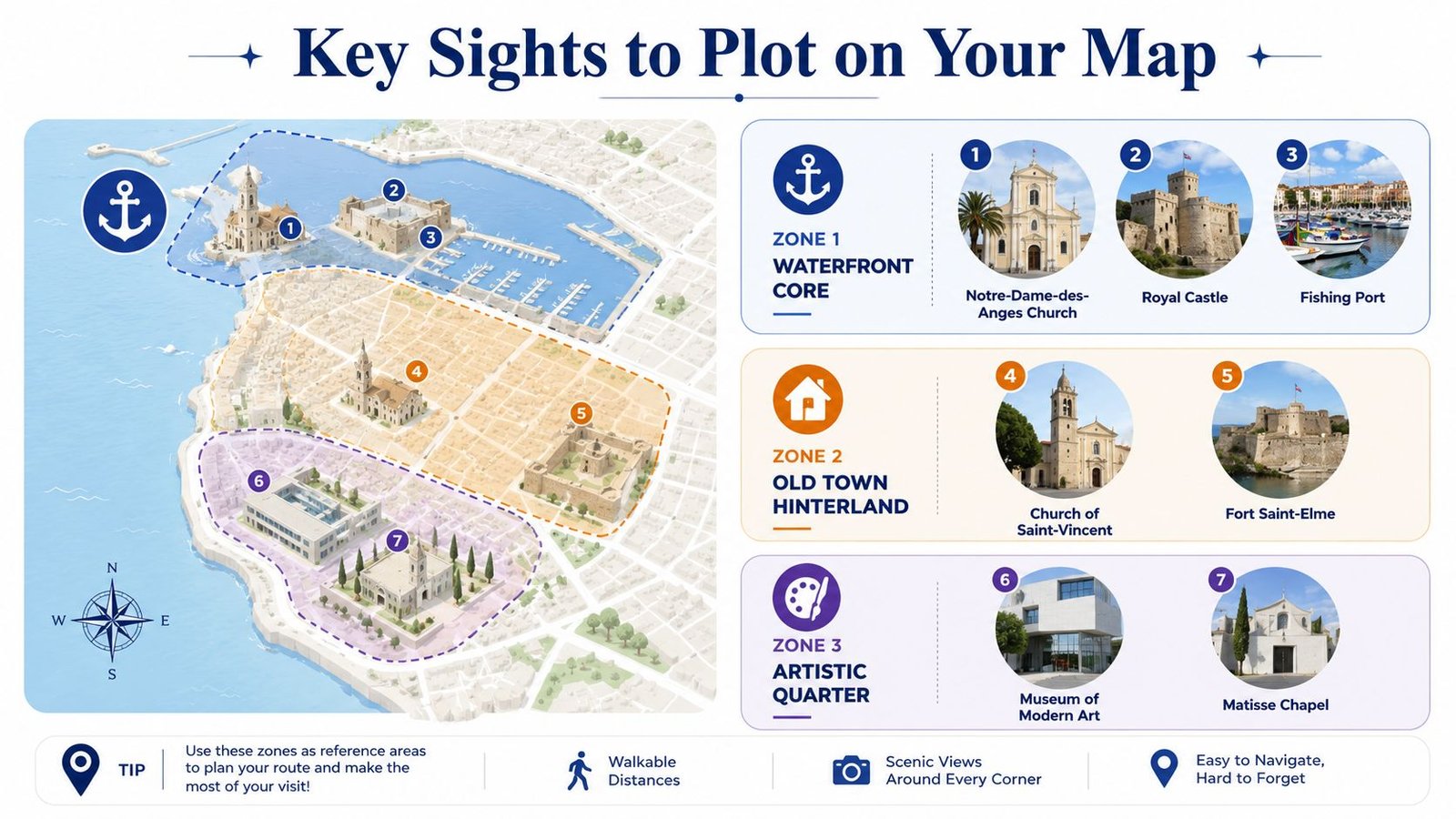
The easiest way to plan Collioure is to divide the town into three map zones. That keeps you from trying to do too much in one sweep, and it helps you match sightseeing to mobility, weather, and time of day.
Waterfront core
This is the part that visitors picture first. Mark Notre-Dame-des-Anges Church, the Royal Castle, and the Fishing Port as one cluster, because they sit close enough to combine into a single slow loop. The area works well for first-time visitors and for anyone who wants the strongest postcard views without a long climb.
Old town hinterland
Move inland and uphill for Church of Saint-Vincent and Fort Saint-Elme. The church area is still manageable on foot, but the routes start to ask more of your legs, and the fort sits higher still. That zone suits visitors who want the classic overlook perspective and don't mind a steeper approach.
Artistic quarter
The more creative side of the town includes the Museum of Modern Art and the Matisse Chapel. That part of the map is useful if you're building a slower half-day around art and context rather than just harbor views. It also helps travelers with limited mobility choose a flatter plan, since not every sight in Collioure requires a hill climb.
Current opening times change more often than map labels do, especially outside peak season. Check locally before you set your route, because a pin on a map doesn't tell you whether a door is open.
Regional Context and Map Planning Beyond Collioure
Collioure makes more sense when you place it inside a triangle formed by Perpignan, the Côte Vermeille, and the Spanish Costa Brava. That geometry is what turns a simple stop into a smarter base for day trips, because the same map that helps you walk the harbor can also help you decide whether you're heading north, south, or into the mountains.
Once Collioure is anchored, places like Figueres, Cadaqués, and the Alberes massif become clearer decisions rather than vague possibilities. The town sits at a point where coast and border meet, so you can move from sea-level lanes to cross-border roads or inland hills without changing the overall rhythm of the trip. That's why a good local map should be saved alongside whatever broader route you're building through southern France and Catalonia.
The 12 August 2026 total solar eclipse matters here only in a planning sense. Collioure's value is its general Pyrenees position, not a guarantee that the town itself sits inside the path of totality, so anyone chasing eclipse conditions should rely on dedicated path-of-totality maps rather than assumptions. For readers checking Spain-side options, the Catalonia-specific view is here: 2026 eclipse planning for Catalonia.
Keep an offline map with the mairie address stored as a fallback reference, because signal and battery are both less trustworthy than a printed pin in a small coastal town. The population figures quoted by different map sources, roughly 2,700 to 3,200 inhabitants depending on source and date (Toponavi's Collioure listing), give you a sense of scale without pretending the number is fixed. Collioure is big enough to have services, small enough that those services can feel stretched in peak season, and that's exactly the balance a traveler should expect.
If you're planning Collioure for a coastal walk, a Spain-linked itinerary, or a viewing trip tied to the 2026 eclipse horizon, save the maps now, print one copy, and check the civic pin before you go. Then use Total Solar Eclipse 2026 Live to compare your broader travel route with the eclipse path and build the rest of your trip around the right locations.